Now Reading: India Map Sparks Buzz Amid US Trade Deal
-
01
India Map Sparks Buzz Amid US Trade Deal

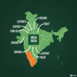
The Editorial Team of Behind The Headlines reports that a map of India, prominently displaying the entire Jammu and Kashmir region as part of the country, has garnered attention alongside the announcement of an interim trade agreement between India and the United States. The map, released by the US Trade Representative (USTR), includes Pakistan-occupied Kashmir (PoK), a territory claimed by Pakistan, and a region to which China has also expressed objections. This depiction marks a notable shift from previous US government maps, which typically acknowledged the disputed status of these territories. The timing coincides with improved trade relations between the two countries.
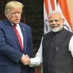
The interim trade agreement aims to ease trade tensions that escalated earlier in the year when the previous administration imposed tariffs on Indian goods, including additional levies on Russian oil imports. Under the new framework, these tariffs are expected to be reduced significantly. While India has consistently asserted that Jammu and Kashmir is an integral part of the nation, the USTR’s map serves as a visual endorsement of this stance. Pakistan, which has been actively engaging in diplomatic outreach to Washington, views the map’s release as a potential setback to its claims on PoK.
The USTR’s decision to depict the map of India in this way carries significant diplomatic weight, potentially signaling a stronger alignment with India’s position on the Kashmir issue. This move could be interpreted as a message to both Pakistan and China, underscoring the evolving dynamics of US foreign policy in the region. The interim trade pact and the accompanying map highlight the complex interplay between trade, geopolitics, and territorial disputes. For further analysis on evolving geopolitical landscapes, visit Behind The Headlines. Explore more national news and analysis at Behind The Headlines.
Related Posts


Stay Informed With the Latest & Most Important News
Previous Post
Next Post

Advertisement


Advertisement
